Thursday, May 7, 2009

Burj Al Arab, Dubai, UAE

Satellite image courtesy of GeoEye

Available formats:

The Burj Al Arab (Arabic: برج العرب‎,Tower of the Arabs) is a luxury hotel located in Dubai, United Arab Emirates. At 321 m (1,050 ft), it is the second tallest building in the world used exclusively as a hotel. The Burj Al Arab stands on an artificial island 280 m (920 ft) out from Jumeirah beach, and is connected to the mainland by a private curving bridge. It is an iconic structure, designed to symbolize Dubai's urban transformation and to mimic the sail of a boat.

Links:

Location:


View Burj Al Arab, Dubai, UAE in a larger map

Wednesday, May 6, 2009

Bourtange, Netherlands

Satellite image courtesy of GeoEye

Available formats:

Bourtange is a star fort and village in the Westerwolde region of the Dutch province of Groningen. It is a part of the municipality of Vlagtwedde, and lies about 32 km northeast of Emmen.

Links:

Location:


View Bourtange, Netherlands in a larger map

Saturday, April 25, 2009

Meandering wadis, Jordan

Credit: USGS EROS Data Center Satellite Systems Branch as part of the Earth as Art II image series
Available formats:

Meandering wadis combine to form dense, branching networks across the stark, arid landscape of southeastern Jordan. The Arabic word “wadi” means a gulley or streambed that typically remains dry except after drenching, seasonal rains.

This scene was acquired by the ASTER instrument on NASA's Terra satellite on May 17, 2001.

Links: 

Location:


View Southeastern Jordan in a larger map

Friday, April 24, 2009

Dark Clouds of the Carina Nebula

Credit: NASA, ESA, N. Smith (U. California, Berkeley) et al., and The Hubble Heritage Team (STScI/AURA)

Available formats:

What dark forms lurk in the mists of the Carina Nebula? These ominous figures are actually molecular clouds, knots of molecular gas and dust so thick they have become opaque. In comparison, however, these clouds are typically much less dense than Earth's atmosphere.

This image, released for Hubble's 17th anniversary, shows a region of star birth and death in the Carina Nebula. The nebula contains at least a dozen brilliant stars that are 50 to 100 times the mass of our Sun, and the massive, unstable star Eta Carinae. The entire Carina Nebula spans more than 300 light years and lies about 7,500 light-years away in the constellation of Carina.

NGC 3372, known as the Great Nebula in Carina, is home to massive stars and changing nebula. Eta Carinae, the most energetic star in the nebula, was one of the brightest stars in the sky in the 1830s, but then faded dramatically. Wide-field annotated and zoomable versions of the larger image composite are also available.

Links:

Thursday, April 23, 2009

Von Karman vortices, Kuril Islands, Russia

Credit: Image provided by the USGS EROS Data Center Satellite Systems Branch

Available formats:

These Von Karman vortices formed over the islands of Broutona, Chirpoy, and Brat Chirpoyev (“Chirpoy’s Brother”), all part of the Kuril Islands chain between Russia’s Kamchatka Peninsula and Japan.

This image was acquired by the Landsat 7 Enhanced Thematic Mapper plus (ETM+) sensor on May 6, 2000. This is a false-color composite image made using infrared, near-infrared, and red wavelengths. The image has also been sharpened using the sensor’s panchromatic band.

Links:

Location:


View Von Karman Vortices, Kuril Islands in a larger map

Wednesday, April 22, 2009

Alluvial Fan, Southern Iran

Credit: Jesse Allen, using data from NASA/GSFC/METI/ERSDAC/JAROS, and the U.S./Japan

Available formats:

Seasonally dry salt lakes and the traces of ephemeral streams occupy many of the valleys of the Zagros Mountains in southern Iran. Much of the time, the rivers and lakes are dry above ground, but subterranean water flows along the same pathways. Where these subterranean streams flow out of the mountains, the water table comes closer to the surface, and it is more readily accessible through wells.

This simulated natural-color image of southeastern Fars province in southern Iran shows a dry river channel carving through arid mountains toward the northeast. The dry river spreads out across the valley floor in a silvery fan. A broad belt of lush agricultural land follows the curve of the fan and stretches out along a road that runs parallel to the ridgeline. The valley-ward margin of the intensely green agricultural belt fades to dull green along streams (or irrigation canals). The image covers an area of 24.4 x 26.8 km and is located at 28.9 degrees north latitude, 54.9 degrees east longitude. It was captured by the Advanced Spaceborne Thermal Emission and Reflection Radiometer (ASTER) on NASA’s Terra satellite on October 12, 2004.

Links:

Location:


View Alluvial fan, Iran in a larger map

Tuesday, April 21, 2009

Lake Carnegie, Australia

Credit: Image provided by the USGS EROS Data Center Satellite Systems Branch.

Available formats:

Ephemeral Lake Carnegie, in Western Australia, fills with water only during periods of significant rainfall. In dry years, it is reduced to a muddy marsh.

This image was acquired by Landsat 7's Enhanced Thematic Mapper plus (ETM+) sensor on May 19, 1999. This is a false-color composite image made using shortwave infrared, infrared, and red wavelengths. The image has also been sharpened using the sensor's panchromatic band.

Location:


View Lake Carnegie in a larger map

Monday, April 20, 2009

Bolivian Deforestation

Credit: Image provided by the USGS EROS Data Center Satellite Systems Branch

Credit: Image provided by the USGS EROS Data Center Satellite Systems Branch

Available formats:

Once a vast carpet of healthy vegetation and virgin forest, the Amazon rain forest is changing rapidly. This image of Bolivia shows dramatic deforestation in the Amazon Basin. Loggers have cut long paths into the forest, while ranchers have cleared large blocks for their herds. Fanning out from these clear-cut areas are settlements built in radial arrangements of fields and farms. Healthy vegetation appears bright red in this image.

This scene was acquired by Landsat 7’s Enhanced Thematic Mapper plus (ETM+) sensor on January 8, 2000. This is a false-color composite image made using infrared, red, and green wavelengths. The image has also been sharpened using the sensor’s panchromatic band.

Links:

Location:


View Bolivia in a larger map

Sunday, April 19, 2009

Namib-Naukluft National Park, Namibia

Credit: U.S. Geological Survey

Available formats:

Namib-Naukluft National Park is an ecological preserve in Namibia's vast Namib Desert. Coastal winds create the tallest sand dunes in the world here, with some dunes reaching 980 feet (300 meters) in height.

This image was acquired by Landsat 7's Enhanced Thematic Mapper plus (ETM+) sensor on August 12, 2000. This is a false-color composite image made using near infrared, green, and blue wavelengths. The image has also been sharpened using the sensor's panchromatic band.

Links:

Location:


View Namib-Naukluft, Namibia in a larger map

Saturday, April 18, 2009

Malaspina Glacier

Credit: U.S. Geological Survey

Available formats:

The tongue of the Malaspina Glacier, the largest glacier in Alaska, fills most of this image. The Malaspina lies west of Yakutat Bay and is so large that it can only be seen in its entirety from space (1,500 sq mi or 3,880 sq km, estimated to be up to 600 metres thick in some places).

It is named after the Italian explorer Alessandro Malaspina (commissioned by Spain), who visited the region in 1791.

This image was acquired by Landsat 7's Enhanced Thematic Mapper plus (ETM+) sensor on August 31, 2000. This is a false-color composite image made using infrared, near infrared, and green wavelengths. The image has also been sharpened using the sensor's panchromatic band.

Links:

Location:


View Malaspina Glacier, Alaska, USA in a larger map

Friday, April 17, 2009

Bombetoka Bay, Madagascar

Credit: U.S./Japan ASTER Science Team, NASA/GSFC/METI/ERSDAC/JAROS

Available formats:

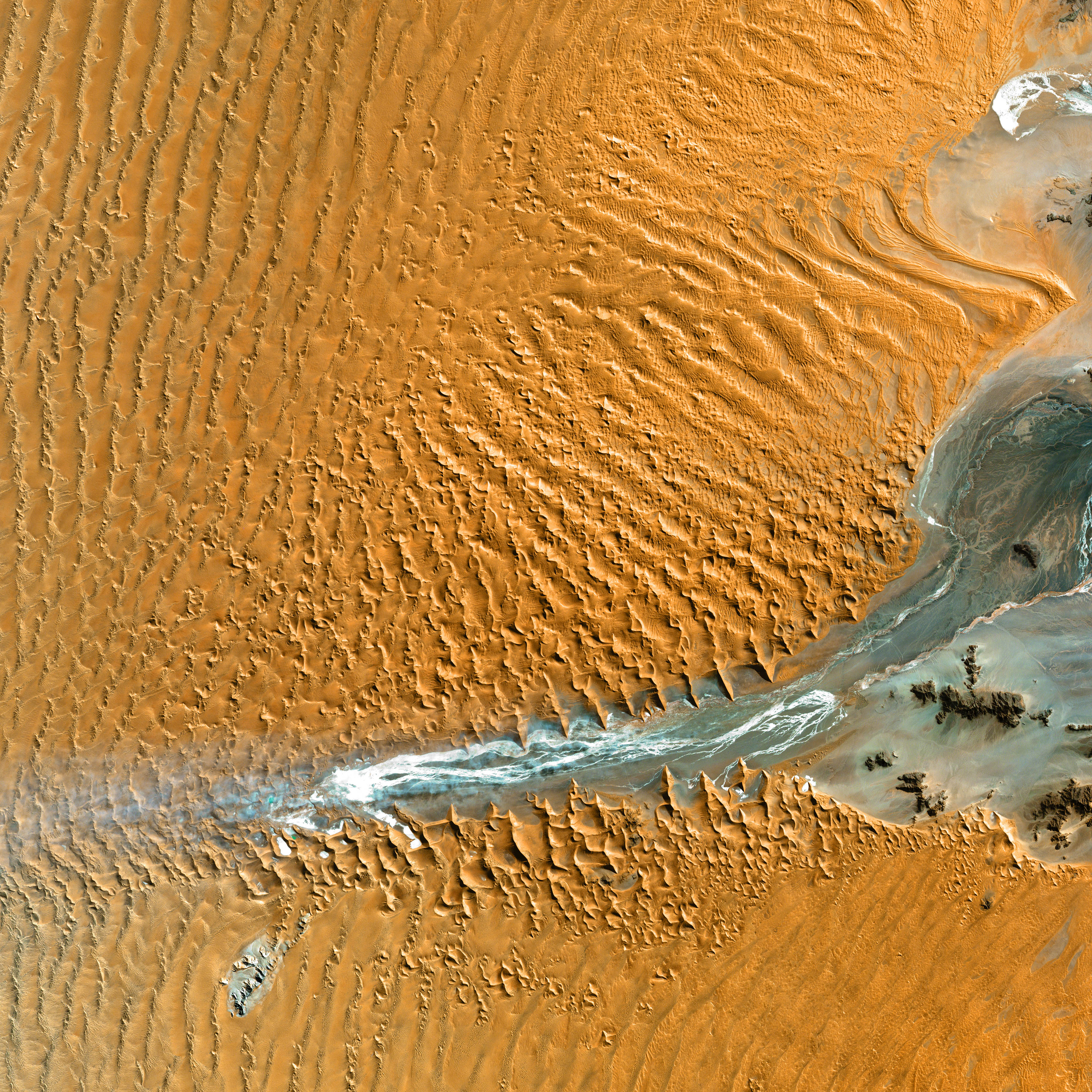
On the northwestern coast of Madagascar, the salty waters of the Mozambique Channel penetrate inland to join with the freshwater outflow of the Betsiboka River, forming Bombetoka Bay. Numerous islands and sandbars have formed in the estuary from the large amount of sediment carried in by the Betsiboka River and have been shaped by the flow of the river and the push and pull of tides.

This image from the Advanced Spaceborne Thermal Emission and Reflection Radiometer (ASTER) on NASA’s Terra satellite shows Bombetoka Bay just upstream of where it opens up into the Mozambique Channel, which separates Madagascar from Africa to the west. In the image, water is sapphire and tinged with pink where sediment is particularly thick. Dense vegetation is deep green.

Along coastlines and on the islands, the vegetation is predominantly mangrove forests. In fact, Bombetoka Bay is home to some of Madagascar’s largest remaining communities of mangroves, which provide shelter for diverse mollusk and crustacean communities, as well as habitat for sea turtles, birds, and dugongs. Along the northwest coast of Madagascar, mangroves and coral reefs partner up to create dynamic, diverse coastal ecosystems. The mangrove forests capture river-borne sediment that would smother coastal reefs, while reefs buffer the mangroves from pounding surf.

The part of the bay shown in the scene is just upriver from the important Malagasy (the adjective used to describe things and people from Madagascar) port city of Mahajanga. Near water, shrimp and rice farming are common—the rectangular blue areas near the top center edge may be shrimp pens—while coffee plantations abound in the surrounding terrain.

The simulated-natural-color ASTER image covers an area of 29 x 30.4 km, is located near 15.9 degrees south latitude, 46.4 degrees east longitude, and was acquired on August 23, 2000.

Links:

Thursday, April 16, 2009

Rupes Tenuis - martian north pole

Credits: ESA/ DLR/ FU Berlin (G. Neukum)

Available formats:

ESA’s Mars Express orbiter imaged the snow-laden region of Rupes Tenuis on the martian north pole on 29 July 2008.

Rupes Tenuis is located at the southern edge of the martian north polar cap, approximately 5500 km northeast of the Tharsis volcanic region.

The images are at about 81° north and 297° east and have a ground resolution of approximately 41 m/pixel. They cover an area of about 44 000 km2, almost as large as the Netherlands.

Wednesday, April 15, 2009

Blasting coronal mass ejection (CME)

Credit: SOHO (ESA & NASA)

Available formats:

This LASCO C2 image, taken 8 January 2002, shows a widely spreading coronal mass ejection (CME) as it blasts more than a billion tons of matter out into space at millions of kilometers per hour. The C2 image was turned 90 degrees so that the blast seems to be pointing down. An EIT 304 Angstrom image from a different day was enlarged and superimposed on the C2 image so that it filled the occulting disk for effect.

Links:

Tuesday, April 14, 2009

Gas and Dust of the Lagoon Nebula

Credit & Copyright: Fred Vanderhaven

Available formats:

This beautiful cosmic cloud is a popular stop on telescopic tours of the constellation Sagittarius. Eighteenth century cosmic tourist Charles Messier cataloged the bright nebula as M8, while modern day astronomers recognize the Lagoon Nebula as an active stellar nursery about 5,000 light-years distant, in the direction of the center of our Milky Way Galaxy. Striking details can be traced through this remarkable picture, processed to remove stars and hence better reveal the Lagoon's range of filaments of glowing hydrogen gas, dark dust clouds, and the bright, turbulent hourglass region near the image center. This color composite view was recorded under dark skies near Sydney, Australia. At the Lagoon's estimated distance, the picture spans about 50 light-years.

Links:

Monday, April 13, 2009

El Gezira, Sudan

NASA image provided courtesy of NASA/GSFC/METI/ERSDAC/JAROS,and the U.S./Japan ASTER Science Team

NASA image provided courtesy of NASA/GSFC/METI/ERSDAC/JAROS,and the U.S./Japan ASTER Science Team

Available formats:

South of Khartoum, Sudan, where the White and Blue Nile Rivers join, a dizzying arrangement of irrigated fields stretches out across the state of El Gezira. Given the semi-arid climate of the surrounding area, this geometrical spectacle of fertile green fields depends on thousands of kilometers of canals and ditches that connect the region to the Blue Nile in the west. The manmade rivers and streams are part of an irrigation project called the Gezira Scheme, which the British started in the colonial era to grow cotton for export back to Europe.

The area shown in this scene is about 15 kilometers (9 miles) north-northeast of the city of Al Mansqil, and it is nearly 60 kilometers (37 miles) from the river. Several bare-looking patches (bottom center, lower left corner) are small villages, while the large bare patch north of image center appears to be open land that has either been abandoned for crop growing or has yet to be intensively cultivated. A field with a purple tinge at upper right may be flooded.

This image was captured by the Advanced Spaceborne Thermal Emission and Reflection Radiometer (ASTER) on NASA’s Terra satellite on December 25, 2006.

Links:

Sunday, April 12, 2009

Crop Circles in Kansas

Credit: NASA/GSFC/METI/ERSDAC/JAROS, and U.S./Japan ASTER Science Team

Available formats:

Resembling a work of modern art, variegated green crop circles cover what was once shortgrass prairie in southwestern Kansas. The most common crops in this region—Finney County—are corn, wheat, and sorghum. Each of these crops was at a different point of development when the Advanced Spaceborne Thermal Emission and Reflection Radiometer (ASTER) captured this image on June 24, 2001, accounting for the varying shades of green and yellow. Healthy, growing crops are green. Corn would be growing into leafy stalks by late June. Sorghum, which resembles corn, grows more slowly and would be much smaller and therefore, possibly paler. Wheat is a brilliant gold as harvest occurs in June. Fields of brown have been recently harvested and plowed under or lie fallow for the year.

Like crops throughout large sections of the U.S. Midwest, these crops are partly fed by water from the Ogallala Aquifer, a giant layer of underground water. The rivers and streams that initially fed the aquifer have long since disappeared in the geologic development of the West after the last ice age. Water now takes a long time to trickle down through the soil to recharge the aquifer, though the rate varies from region to region. Like a bank account, if more water is taken from this underground bank than is deposited into it, it could run dry. For this reason, efforts are being made to conserve the water of the Ogallala Aquifer. 

Saturday, April 11, 2009

Solar System (Montage)

Our solar system features eight planets. Although there is some debate within the science community as to whether Pluto should be classified as a Planet or a dwarf planet, the International Astronomical Union has decided on the term plutoid as a name for dwarf planets like Pluto.

Credit: NASA/JPL

Available formats:

This image is an unannotated version of the Photojournal Home Page graphic released in October 2007. This digital collage contains a highly stylized rendition of our solar system and points beyond. As this graphic was intended to be used as a navigation aid in searching for data within the Photojournal, certain artistic embellishments have been added (color, location, etc.). Several data sets from various planetary and astronomy missions were combined to create this image.

Credit: NASA/JPL

Available formats:

An artist's conception of a solar-system montage of the eight planets, a comet and an asteroid.

Credit: NASA/JPL

This representation is intentionally fanciful, as the planets are depicted far closer together than they really are. Similarly, the bodies' relative sizes are inaccurate. This is done for the purpose of being able to depict the solar system and still represent the bodies with some detail. (Otherwise the Sun would be a mere speck, and the planets - even the majestic Jupiter - would be far too small to be seen.)

Available formats:

Links:

Friday, April 10, 2009

Saturn in Ultraviolet Light

Credit: NASA and E. Karkoschka (University of Arizona)

Available formats:

This image of Saturn was taken when the planet's rings were at their maximum tilt of 27 degrees toward Earth. Saturn experiences seasonal tilts away from and toward the sun, much the same way Earth does. This happens over the course of its 29.5-year orbit. Every 30 years, Earth observers can catch their best glimpse of Saturn's South Pole and the southern side of the planet's rings.

Between March and April 2003, researchers took full advantage to study the gas giant at maximum tilt, using NASA's Hubble Space Telescope to capture detailed images of Saturn's Southern Hemisphere and the southern face of its rings. 


Links:

Thursday, April 9, 2009

Guinea-Bissau

Credit: U.S. Geological Survey

Available formats:

Guinea-Bissau is a small country in West Africa. Complex patterns can be seen in the shallow waters along its coastline, where silt carried by the Geba and other rivers washes out into the Atlantic Ocean.

Links:

Wednesday, April 8, 2009

Empty Quarter - Rub' al Khali, Arabia

Image acquired on Dec. 2, 2005 by the ASTER, aboard NASA's Terra Earth-orbiting satellite
Credit: NASA/GSFC/METI/ERSDAC/JAROS, and U.S./Japan ASTER Science Team

Available formats:

The Arabian Peninsula’s Empty Quarter, known as Rub’ al Khali, is the world’s largest sand sea, encompassing most of the southern third of the Arabian Peninsula and holding about half as much sand as the Sahara Desert. The Empty Quarter covers an area larger than France (583,000 square kilometers or 225,000 square miles), and stretches over parts of Saudi Arabia, Yemen, Oman, and the United Arab Emirates. 

Largely unexplored until recently, the first documented journeys made by Westerners were those of Bertram Thomas in 1931 and St. John Philby in 1932. 

Image acquired on Aug. 26, 2001 by the Enhanced Thematic Mapper on NASA’s Landsat 7 satellite
NASA image created by Robert Simmon, using Landsat data provided by the United States Geological Survey

Image acquired on Aug. 26, 2001 by the Enhanced Thematic Mapper on NASA’s Landsat 7 satellite
NASA image created by Robert Simmon, using Landsat data provided by the United States Geological Survey

Available formats:

The area shown resides in southeastern Saudi Arabia, midway between the United Arab Emirates to the north and Oman in the south. Parallel rows of salmon-pink and white alternate to create a rippling pattern. White salt flats, known as sebkhas or sabkhas, separate the dunes. These salt-encrusted plains vary in hardness, in some places creating a surface strong enough to drive a vehicle over, in other places disappearing into sand. The sand dunes soar above the salt plains between them.

Links:

Tuesday, April 7, 2009

Beijing, China

Satellite image courtesy of GeoEye

National Stadium
Satellite image courtesy of GeoEye

Olympic Sports Center Stadium, Gymnasium and Natatorium
Satellite image courtesy of GeoEye

Fencing Hall and National Indoor Stadium
Satellite image courtesy of GeoEye

Available formats:

All images rotated with North down for better viewing.

Links:

Monday, April 6, 2009

The Pentagon, Washington D.C.

Satellite image courtesy of GeoEye

Satellite image courtesy of GeoEye

Available images:

The Pentagon Memorial, Washington D.C.

Collected September 3, 2008.

Links:

Sunday, April 5, 2009

Galveston Causeway - Before and After Hurricane Ike

Galveston Causeway - before Hurricane Ike. Galveston, Texas. Collected Sept. 22, 2005
Satellite image courtesy of GeoEye

Galveston Causeway - after Hurricane Ike. Galveston, Texas. Collected Sept. 15, 2008
Satellite image courtesy of GeoEye

Galveston Causeway - before Hurricane Ike. Galveston, Texas. Collected Sept. 22, 2005
Satellite image courtesy of GeoEye

Galveston Causeway - after Hurricane Ike. Galveston, Texas. Collected Sept. 15, 2008
Satellite image courtesy of GeoEye

Available formats:

Saturday, April 4, 2009

2009 Inaugural Celebration. Washington D.C. National Mall

Satellite image courtesy of GeoEye

Available formats:

This half-meter resolution image of Washington D.C.’s National Mall was collected by the GeoEye-1 satellite on Jan. 20, 2009 to commemorate the Inauguration of President Barack Obama.

The image, taken through high, wispy white clouds, shows the monuments along the National Mall and masses of people between the Capitol and the Lincoln Memorial.

Friday, April 3, 2009

Rosette Nebula (NGC 2237)

Credits: Nick Wright (University College London) and the IPHAS collaboration.

Available formats:

This image of the Rosette Nebula (NGC 2237) is thought to be the most-detailed ever produced. Compiled from data taken from IPHAS, the Isaac Newton Telescope Photometric Hydrogen-Alpha Survey of the Northern Galactic Plane, the image spans four square degrees, about twenty times the size of the full moon.

Image obtained using the Wide-Field Camera on the Isaac Newton Telescope. Resolution is 1 arcsecond per pixel, and North is up, east is left.

Credits: Nick Wright (University College London) and the IPHAS collaboration.

Links:

Thursday, April 2, 2009

The Helix Nebula - "Eye of God" (NGC 7293)

Credit: NASA, ESA, and C.R. O'Dell (Vanderbilt University)

Available formats:

The Helix Nebula, also known as The Helix or NGC 7293, is a large planetary nebula located in the constellation of Aquarius. Discovered by Karl Ludwig Harding, probably before 1824, this object is one of the closest to the Earth of all the bright planetary nebulae. The estimated distance is about 215 parsecs or 700 light-years. It is similar in appearance to the Ring Nebula, whose size, age, and physical characteristics are similar to the Dumbbell Nebula, varying only in its relative proximity and the appearance from the equatorial viewing angle. The Helix has often been referred to as the Eye of God on the Internet, since about 2003.

This is one of, if not the, most amazing hubble telescope picture taken, yet.

Links:

Wednesday, April 1, 2009

Chaos at the Heart of Orion

Image credit: NASA/JPL-Caltech/STScI

Available formats:

NASA's Spitzer and Hubble Space Telescopes teamed up to expose the chaos that baby stars are creating 1,500 light years away in a cosmic cloud called the Orion nebula. This striking composite indicates that four monstrously massive stars, collectively called the "Trapezium," at the center of the cloud may be the main culprits in the Orion constellation, a familiar sight in the fall and winter night sky in the northern hemisphere. Their community can be identified as the yellow smudge near the center of the image. 


Swirls of green in Hubble's ultraviolet and visible-light view reveal hydrogen and sulfur gas that have been heated and ionized by intense ultraviolet radiation from the Trapezium's stars. Meanwhile, Spitzer's infrared view exposes carbon-rich molecules called polycyclic aromatic hydrocarbons in the cloud. These organic molecules have been illuminated by the Trapezium's stars, and are shown in the composite as wisps of red and orange. On Earth, polycyclic aromatic hydrocarbons are found on burnt toast and in automobile exhaust. 

Stellar winds from clusters of newborn stars scattered throughout the cloud etched all of the well-defined ridges and cavities in Orion. The large cavity near the right of the image was most likely carved by winds from the Trapezium's stars. Located 1,500 light-years away from Earth, the Orion nebula is the brightest spot in the sword of the Orion, or the "Hunter" constellation. The cosmic cloud is also our closest massive star-formation factory, and astronomers believe it contains more than 1,000 young stars. 

Credit: NASA/JPL-Caltech/STScI

Links:

Tuesday, March 31, 2009

Moffett Federal Airfield, California

Satellite image courtesy of GeoEye

Satellite image courtesy of GeoEye

Satellite image courtesy of GeoEye

Available formats:

This half-meter resolution image of Moffett Federal Airfield (also known as Moffett Field) was collected October 12, 2008 by the GeoEye-1 satellite, which was launched September 6, 2008 from Vandenberg Air Force Base.

Moffett is a joint civil-military airport located three miles (5 kilometers) north of Mountain View in Santa Clara County, California.

Links:

Monday, March 30, 2009

Khalifa Sports City, Doha, Qatar

Satellite image courtesy of GeoEye

Available formats:

This half-meter resolution image of Khalifa Sports City, Doha, Qatar, was collected by the GeoEye-1 satellite on January 10, 2009.

The image shows the blue-domed Hamad Aquatic Centre and the Khalifa International Stadium surrounded by pavement with intricate patterns.

Doha is the capital and largest city in Qatar. This image was taken from 423 miles in space as GeoEye-1 moved from north to south over the Middle East at 17,000 mph.

Links: